Identifier
GGE
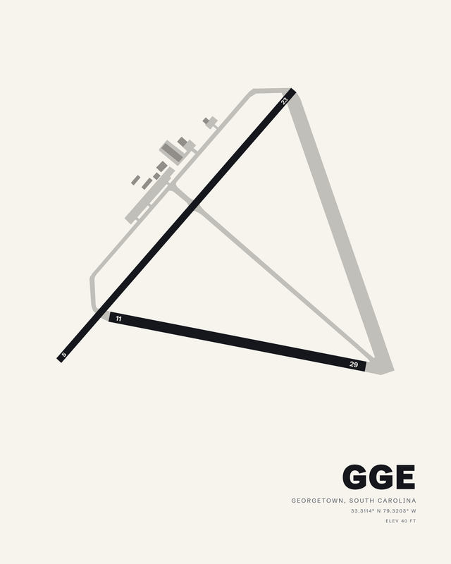
A runway diagram map print of Georgetown County Airport (GGE), made from the airport's own layout for the place it holds in your life. Choose your colorway and your format: a fine art giclée print on cotton paper, a framed fine art print, a glossy metal print or a digital download.
Your fine art print is made to order with pigment inks on heavyweight, 100% cotton Hot Press paper, a 330 gsm sheet with a high color gamut and deep black density. The acid-free, archival-grade paper has a smooth matte surface. Supplied unframed, ready for your own frame.
Choosing a gift? Read our gift guide for pilots.
Physical prints are made to order in 2 to 3 business days; shipping time is added on top and varies by your location and the method you choose. Standard shipping is free across the US. Orders containing only paper prints ship flat, though paper may retain a slight curl; orders with framed or metal pieces ship in separate boxes. Digital downloads are delivered by email, so there is nothing to ship.
The Digital Download is a JPEG at 300 dpi, sized for 24 by 30 inches. The digital add-on matches the selected physical print size at 300 dpi. Download links arrive by email and stay active for 30 days; save the file within that time and keep it for personal, non-commercial use. No physical item is shipped.
Physical products have a 30-day money-back guarantee. Contact us within 30 days of delivery to request a refund; we may require a return before issuing it.
Digital downloads are non-refundable once delivered, except where required by law or where AirportPrints determines that a delivery failure or technical issue was caused by AirportPrints.
Fine Art Print: pigment giclée printing on heavyweight 330 gsm (17 mil), 100% cotton Hot Press paper, on regularly calibrated giclée printers. The paper is acid-free and archival-grade, with a smooth matte surface and the high color gamut and black density that let a dark ground and fine linework keep their depth. Supplied unframed, with no added white margin, ready for your own frame.
Framed Fine Art Print: the same cotton fine art paper in a 1.25 inch solid wood frame. A white, acid-free, 4-ply mat with a 45-degree bevel and optical-grade, shatter-resistant clear acrylic (safer to ship than glass) are included. The print is mounted to foam core for a flat presentation, with a kraft paper dust cover and installed hanging wire on the back.
Glossy Metal Print: the image is transferred by dye sublimation into polymer-coated aluminum with a glossy white base. The 1.14 mm panel has a scratch- and water-resistant surface, with a hidden inset mount that positions it about 3/4 inch off the wall. Display indoors, away from direct sunlight.
Digital Download: a high-resolution JPEG for personal, non-commercial use. No physical paper, frame, or metal panel is included.
Fine Art Print: 8 x 10, 16 x 20, and 24 x 30 inches.
Framed Fine Art Print: 8 x 10, 16 x 20, and 24 x 30 inches, measured across the mat and acrylic area inside the frame. The mat sits within that area, so the visible image is about 6 x 8, 12 x 16, or 18 x 24 inches. The outside frame is larger than the listed size.
Glossy Metal Print: 8 x 10, 16 x 20, and 24 x 30 inches. During sublimation, 1/8 to 1/4 inch of the artwork may be cropped, so the printed edge can differ slightly from the preview.
Digital Download: a 7200 x 9000 pixel JPEG at 300 dpi for 24 x 30 inch printing. A digital add-on instead matches the selected physical size: 8 x 10, 16 x 20, or 24 x 30 inches at 300 dpi.
This is Georgetown's own layout, the way its runways run and the taxiways thread between them, composed into a print you will want to look at every day. Not a stock template with a new name on it.
Heavyweight 330 gsm, 100% cotton Hot Press paper, acid-free and archival-grade. Its high color gamut and black density give the runways real depth, and pigment inks keep the fine detail crisp on a smooth matte surface.
Frame it in 1.25 inch solid wood, black, white or natural oak, with the white beveled mat, optical-grade clear acrylic and hanging wire included. Or choose glossy metal: dye sublimation into aluminum, floated about 3/4 inch off the wall on a hidden mount.
Composed from published airport information and available field depictions as original wall art. Learn how AirportPrints maps take shape.
Georgetown County (GGE) has two asphalt runways, and on this airport map print they read as a narrow V of dark pavement. Runway 05/23 is the long side at 6,005 feet by 100 feet, running from the lower left corner up toward the top right. Runway 11/29 is shorter and wider, 4,539 feet by 150 feet, and it crosses the long runway just above the 5 threshold before running out to the right. The two strips share one corner and then pull apart, which is what gives the drawing its wedge.
The field was built in 1941 by the United States Navy and passed to civil authorities in 1944, after which it was developed into a public airport. It is county-owned and public-use, and it was categorized as a general aviation facility in the National Plan of Integrated Airport Systems for 2011 through 2015. None of that is written on the sheet. What you get instead is the pavement itself, plotted from published airport information: the two runways in solid dark ink, the taxiways and apron in a pale grey outline that closes a wide triangle behind them, and a small cluster of buildings near the top left.
As artwork the piece is mostly restraint. Threshold numbers (5, 23, 11, 29) sit in white boxes at the four ends, the identifier GGE is set large in the lower right, and the elevation of 40 feet runs under the coordinates in small caps. Everything else is open field. The composition leans, so it holds a wall better off-center than dead middle, and the long diagonal of 05/23 gives the eye an obvious line to follow. The Myrtle Beach print can hang beside this one.
Physical pieces are made to order as a Fine Art Print, a Framed Fine Art Print or a Glossy Metal Print, and there is a Digital Download if you would rather handle the file yourself. The geometry stays the same in every size; the colorway you choose decides how hard the runways read against the background.
Two. The print shows runway 05/23 and runway 11/29 crossing near the 5 end, so the pair forms a narrow V rather than a cross or a pair of parallels.
Runway 05/23 is 6,005 feet long and 100 feet wide, the longer of the two. Runway 11/29 is 4,539 feet long and 150 feet wide. Both surfaces are asphalt.
40 feet. It appears as ELEV 40 FT in the title block under the coordinates, alongside the identifier GGE.
GGE is the identifier for Georgetown County, and it is the code set in large type in the lower right of the sheet. The airport name and the runway designators 05/23 and 11/29 complete the labelling.
The runway lengths, widths and relative positions are plotted from published runway data, so the proportions of 05/23 against 11/29 are held. This is a designed diagram rather than a chart, and fine details may be simplified or omitted. Pavement markings, lighting and signage are examples of what is left out.
Yes, particularly for someone with a connection to Georgetown County. The runway figures and the identifier carry the meaning, so it lands as a personal piece without needing explanation, and the format and colorway you choose can be matched to the room it is going into.