Identifier
FUL
A runway diagram map print of Fullerton Municipal Airport (FUL), made from the airport's own layout for the place it holds in your life. Choose your colorway and your format: a fine art giclée print on cotton paper, a framed fine art print, a glossy metal print or a digital download.
Your fine art print is made to order with pigment inks on heavyweight, 100% cotton Hot Press paper, a 330 gsm sheet with a high color gamut and deep black density. The acid-free, archival-grade paper has a smooth matte surface. Supplied unframed, ready for your own frame.
Choosing a gift? Read our gift guide for pilots.
Physical prints are made to order in 2 to 3 business days; shipping time is added on top and varies by your location and the method you choose. Standard shipping is free across the US. Orders containing only paper prints ship flat, though paper may retain a slight curl; orders with framed or metal pieces ship in separate boxes. Digital downloads are delivered by email, so there is nothing to ship.
The Digital Download is a JPEG at 300 dpi, sized for 24 by 30 inches. The digital add-on matches the selected physical print size at 300 dpi. Download links arrive by email and stay active for 30 days; save the file within that time and keep it for personal, non-commercial use. No physical item is shipped.
Physical products have a 30-day money-back guarantee. Contact us within 30 days of delivery to request a refund; we may require a return before issuing it.
Digital downloads are non-refundable once delivered, except where required by law or where AirportPrints determines that a delivery failure or technical issue was caused by AirportPrints.
Fine Art Print: pigment giclée printing on heavyweight 330 gsm (17 mil), 100% cotton Hot Press paper, on regularly calibrated giclée printers. The paper is acid-free and archival-grade, with a smooth matte surface and the high color gamut and black density that let a dark ground and fine linework keep their depth. Supplied unframed, with no added white margin, ready for your own frame.
Framed Fine Art Print: the same cotton fine art paper in a 1.25 inch solid wood frame. A white, acid-free, 4-ply mat with a 45-degree bevel and optical-grade, shatter-resistant clear acrylic (safer to ship than glass) are included. The print is mounted to foam core for a flat presentation, with a kraft paper dust cover and installed hanging wire on the back.
Glossy Metal Print: the image is transferred by dye sublimation into polymer-coated aluminum with a glossy white base. The 1.14 mm panel has a scratch- and water-resistant surface, with a hidden inset mount that positions it about 3/4 inch off the wall. Display indoors, away from direct sunlight.
Digital Download: a high-resolution JPEG for personal, non-commercial use. No physical paper, frame, or metal panel is included.
Fine Art Print: 8 x 10, 16 x 20, and 24 x 30 inches.
Framed Fine Art Print: 8 x 10, 16 x 20, and 24 x 30 inches, measured across the mat and acrylic area inside the frame. The mat sits within that area, so the visible image is about 6 x 8, 12 x 16, or 18 x 24 inches. The outside frame is larger than the listed size.
Glossy Metal Print: 8 x 10, 16 x 20, and 24 x 30 inches. During sublimation, 1/8 to 1/4 inch of the artwork may be cropped, so the printed edge can differ slightly from the preview.
Digital Download: a 7200 x 9000 pixel JPEG at 300 dpi for 24 x 30 inch printing. A digital add-on instead matches the selected physical size: 8 x 10, 16 x 20, or 24 x 30 inches at 300 dpi.
This is Fullerton's own layout, the way its runways run and the taxiways thread between them, composed into a print you will want to look at every day. Not a stock template with a new name on it.
Heavyweight 330 gsm, 100% cotton Hot Press paper, acid-free and archival-grade. Its high color gamut and black density give the runways real depth, and pigment inks keep the fine detail crisp on a smooth matte surface.
Frame it in 1.25 inch solid wood, black, white or natural oak, with the white beveled mat, optical-grade clear acrylic and hanging wire included. Or choose glossy metal: dye sublimation into aluminum, floated about 3/4 inch off the wall on a hidden mount.
Composed from published airport information and available field depictions as original wall art. Learn how AirportPrints maps take shape.
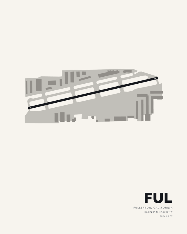
Fullerton Municipal (FUL) is a single-runway field, and the print keeps that honest: runway 06/24, 3,121 feet long and 75 feet wide, drawn as one dark asphalt stroke running from the lower left of the field up toward the upper right. Nothing crosses it. The 6 marker sits at the west end, the 24 marker at the east, and the strip tilts just off horizontal, which is where the composition gets its motion.
The field sits in the southwestern corner of Fullerton on Commonwealth Avenue, northeast of the junction of the Santa Ana (I-5) and Riverside (SR 91) Freeways, with the airport and its industrial park surrounded by residential areas. That containment shows up in the drawing. Rows of hangar and apron shapes stack tight along both sides of the runway, packed inside a boundary that bends and steps to fit what is around it. Fullerton is a regional relief airport in Orange County, owned and operated by the City of Fullerton, and the airport's official birthday is 1927, when the city council approved the ordinance that turned an abandoned sewer farm into a landing field. Its control tower, built in 1959, was the first in Orange County.
On a wall, a one-runway field reads differently from a sprawling hub. There is a single line to follow and a lot of quiet space around it, so the diagonal carries the whole piece. The layout is plotted from published airport information for cycle 2610, effective 2026-09-03, with the identifier, city and state, coordinates and the 96 foot field elevation set into the lower corner. Depending on the colorway you choose, that runway reads as a hard dark bar or a bright cut across the field.
One. Runway 06/24 is the only runway at FUL, and the print draws it as a single diagonal strip with taxiways and aprons banked along both sides. There is no crossing runway to look for.
Runway 06/24 is 3,121 feet long and 75 feet wide, with an asphalt surface. That is the longest runway on the field, because it is the only one.
FUL is Fullerton Municipal Airport in Fullerton, California, at roughly 33.8720 N, 117.9798 W. Field elevation is 96 feet, and both the coordinates and the elevation are printed on the artwork. FUL is the airport's three letter identifier, the one pilots and charts use for the field.
The drawing is composed from published airport information for cycle 2610, so the runway designators, the proportions of 06/24 and the shape of the field boundary all come from that data. This is wall art rather than a navigation document, and fine details may be simplified or omitted. Pavement markings, lighting and signage are examples of what is left out to keep the diagonal readable from across a room.
Sizes run small to large, so FUL can sit as a small piece beside a desk or hold a wall on its own at the largest size. Finishes are Fine Art Print, Framed Fine Art Print, Glossy Metal Print and Digital Download. The physical pieces are made to order; the digital option is a file you download. A single runway field like this one scales well, because the drawing stays legible when the sheet is small.
It does, particularly for anyone who learned to fly, based an aircraft or logged time at Fullerton. The identifier, coordinates and elevation are printed small enough to read up close, so the recipient gets a specific field rather than a generic aviation image.